
User:Olahus

| This is a Wikipedia user page. This is not an encyclopedia article or the talk page for an encyclopedia article. If you find this page on any site other than Wikipedia, you are viewing a mirror site. Be aware that the page may be outdated and that the user whom this page is about may have no personal affiliation with any site other than Wikipedia. The original page is located at https://en.wikipedia.org/wiki/User:Olahus. |

Beliefs
|

| |||
Hi! I am the user Olahus. I am interested in the history and geography of Central, Eastern and Southeastern Europe.
I am a registered user since May 2006.

Viviparus georgianus, commonly known as the banded mystery snail, is a species of large freshwater snail in the family Viviparidae, the river snails. It is native to North America, generally found from the northeastern United States to Florida and the Gulf of Mexico, and thrives in eutrophic lentic environments such as lakes, ponds and some low-flow streams. The snail has two distinct sexes and reproduces more than once in a lifetime, with females laying eggs singly in albumen-filled capsules. It feeds on diatom clusters found on silt and mud substrates, but it may also require the ingestion of some grit to be able to break down algae. This image shows five views of a 2.1 cm high (0.83 in) V. georgianus shell, originally collected in the U.S. state of Georgia and now in the collection of the State Museum of Natural History Karlsruhe in Germany.Photograph credit: H. Zell
Images uploaded by me[edit]
Maps created by me[edit]

.PNG)
.PNG)
.PNG)
.PNG)
.PNG)


.png)

.PNG)
.PNG)
.PNG)


.PNG)


Scanned images[edit]
-
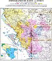
 Ethnic map of the Balkan Peninsula (1898)
 -
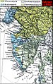
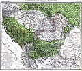
 The Austrian Empire during the XVII century
 -
 The Carolingian Empire after the Treaty of Verdun
 -
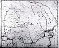
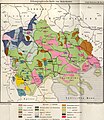
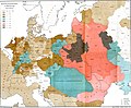
 Ethnic map of European Russia before the First World War
 -
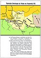
 Ethnographic map of Dobruja (1918)
 -
 The Principality of Montenegro in 1862
 -
 Major Lithuanian linguistic areal in 1876.
 -
 Ethnic Germans in Hungary and parts of adjacent Austrian territories, census 1890
 -
 Demographic map of Italy and surroundung regions (1859)
 -
 Linguistic map of Slovenia and surrounding regions (census 1880)
 -
 Linguistic map of Istria (census 1880)
 -
 The Romanian Old Kingdom (1901)
 -
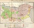
 Bulgaria in 1901
 -
 General map of Rumania (1967)
 -
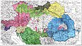
 Confessions in Central Europe
 -
 Bukovina in 1901
 -
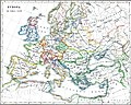
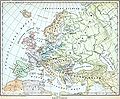 Political map of Europe (1899)
 -
 Political map of Asia (1899)
 -
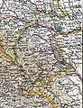
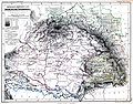
 Main subdivisions of Austria-Hungary (1899).
 -
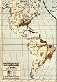
 Political map of South America (1899)
 -
 Extermination of the American Bison to 1889
 -
 The density of the railway net in Europe (1902)
 -
 Map of Greece and European Turkey (1829)
 -
-
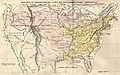 The United States in 1829
 -
 Europe in 1828
 -
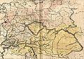 Austria-Hungary in 1828
 -
 The German confederation (1828)
 -
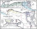
 The Ottoman Empire in Asia (1829)
 -
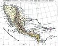
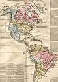 The American continent in 1828
 -
 Africa in 1828
 -
 Asia in 1829
 -
 The Russian Empire in 1828
 -
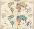
 The world map (1829)
 -
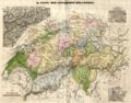 Historical map of Switzerland
 -
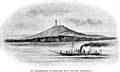
 The Lake Lucerne (1829)
 -
-

-

-

-

-
-

-

-
-

-
-

-
-
-

-

-
-
-

-

-
-

-

-

-

-
-
-

-

-

-
-
-

-

-

-
-
-

-
-

-
-

-

-
-

-

-

-

-

-
-
-

-

-
-

-

-
 Ethnographic map of the Epirus region, 1878. Greek point of view
 -
 Walser settlements in northwestern Italy


.JPG)

.JPG)


.jpg)
.JPG)


.JPG)


.JPG)
.jpg)
.JPG)


.JPG)


_1892.JPG)

.JPG)
.jpg)

.JPG)


.jpg)

.JPG)

.jpg)


.JPG)
.jpg)

.jpg)
.jpg)


.jpg)


.JPG)


