
File:A map of a part of Yucatan, or of that part of the eastern shore within the Bay of Honduras alloted to Great Britain for the cutting of logwood, in consequence of the convention signed with Spain on LOC 86692592.tif

Size of this JPG preview of this TIF file: 800 × 576 pixels. Other resolutions: 320 × 231 pixels | 640 × 461 pixels | 1,024 × 738 pixels | 1,280 × 922 pixels | 2,560 × 1,844 pixels | 10,568 × 7,614 pixels.
Original file (10,568 × 7,614 pixels, file size: 230.21 MB, MIME type: image/tiff)
| This is a file from the Wikimedia Commons. Information from its description page there is shown below. Commons is a freely licensed media file repository. You can help. |
Summary
| Warning | The original file is very high-resolution. It might not load properly or could cause your browser to freeze when opened at full size. |
|---|
| Description |
English: Covers Belize. Relief shown by hachures. Depths shown by soundings. Includes descriptive index and inset of "Mosquitia or the Mosquito Shore with the eastern part of Yucatan as far as the 20th degree of north latitude," ca. 1:5,300,000. Available also through the Library of Congress Web site as a raster image. Vault |
||
| Title | A map of a part of Yucatan, or of that part of the eastern shore within the Bay of Honduras alloted to Great Britain for the cutting of logwood, in consequence of the convention signed with Spain on the 14th July 1786 | ||
| Shelf ID | G4820 1787 .F23 | ||
| Date | |||
| Source | https://www.loc.gov/item/86692592/ | ||
| Author | Faden, William | ||
| Permission (Reusing this file) |
|
||
| Other versions |
|
||
| Location | Belize | ||
| Part of | American Memory · General Maps · Catalog · Geography And Map Division | ||
| Subject | Maps · Early Works To 1800 · Belize |


Licensing
|
This is a faithful photographic reproduction of a two-dimensional, public domain work of art. The work of art itself is in the public domain for the following reason:
The official position taken by the Wikimedia Foundation is that "faithful reproductions of two-dimensional public domain works of art are public domain".
This photographic reproduction is therefore also considered to be in the public domain in the United States. In other jurisdictions, re-use of this content may be restricted; see Reuse of PD-Art photographs for details. | ||||
File history
Click on a date/time to view the file as it appeared at that time.
| Date/Time | Thumbnail | Dimensions | User | Comment | |
|---|---|---|---|---|---|
| current | 17:54, 7 June 2018 | 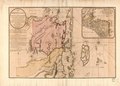 | 10,568 × 7,614 (230.21 MB) | Fæ | LOC Maps https://www.loc.gov/item/86692592/ #23005 |
File usage
The following pages on the English Wikipedia use this file (pages on other projects are not listed):